Welcome to the Hardcore Husky Forums. Folks who are well-known in Cyberland and not that dumb.
PM to Death
Comments
-
Houston say:

-
http://abcnews.go.com/Technology/wireStory/big-melt-antarcticas-retreating-ice-shape-earth-29263411HoustonHusky said:
No, I posted links to 2 sites that had actual data. You posted a link to a story that had some guy saying the sky is falling.2001400ex said:
I'm pretty sure I posted a dispute....HoustonHusky said:Already posted and measured by satellite.
Moron.
There have been satellite images since something like the 70s that show pictures of the Antarctica, and those show increasing overall ice coverage (in one of my links). Simple fact to most (but I'm sure not you...).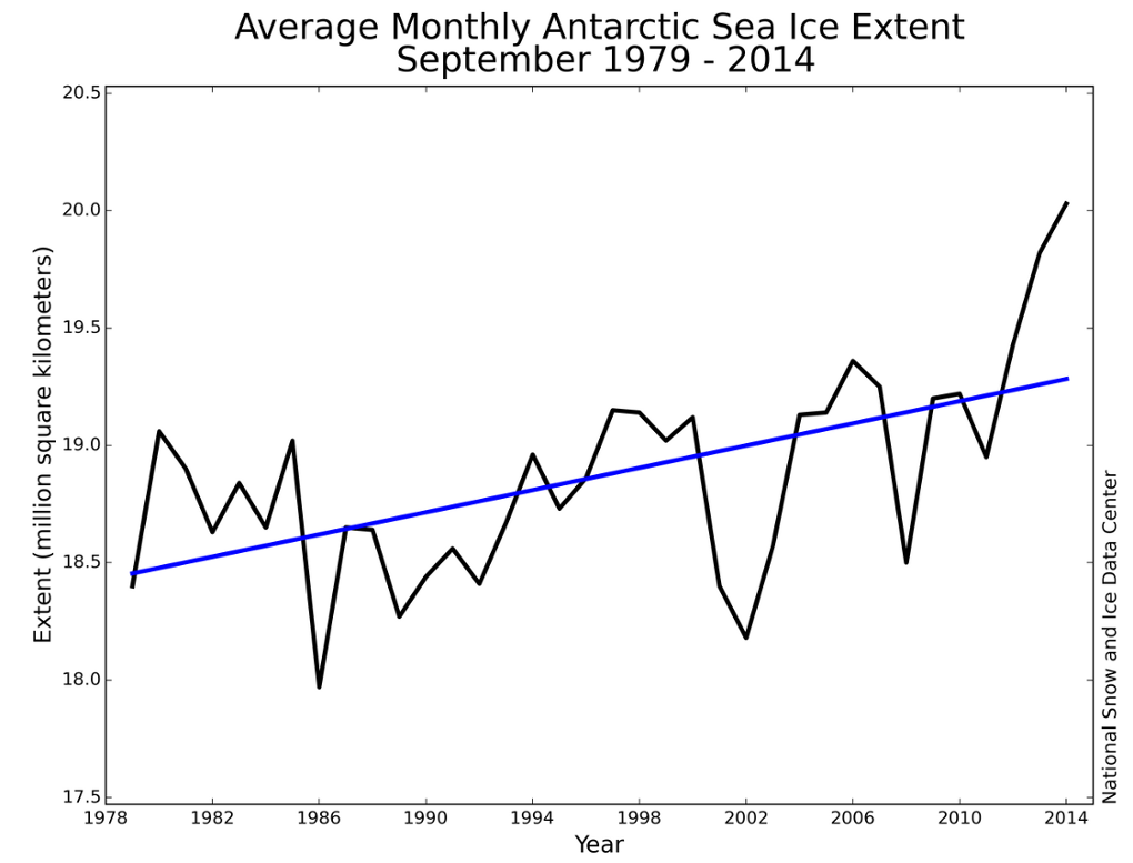
To balance that, there have been all sorts of scientists down there trying to find some way to measure how much ice is underneath to say 'even though the coverage is up, the overall amount must be down'. The methods and data sets are pretty arbitrary and the data is anything but consistent. The latest (and probably best) is a satellite that got launched in 2010 to measure heights of the ice, and that is where some of the latest numbers come from. Although it is better, believing a brand new measurement system with a relatively small time window suddenly proves all then you have to be FS.
Oh yeah...
Learn the difference between sea ice and land ice. Question for you when ice from the land moves and goes somewhere, where do you think that somewhere is? -
Fixed for you.2001400ex said:HoustonHusky said:
No, I posted links to 2 sites that had actual data. You posted a link to a story that had some guy saying the sky is falling.2001400ex said:
I'm pretty sure I posted a dispute....HoustonHusky said:Already posted and measured by satellite.
Moron.
There have been satellite images since something like the 70s that show pictures of the Antarctica, and those show increasing overall ice coverage (in one of my links). Simple fact to most (but I'm sure not you...).
To balance that, there have been all sorts of scientists down there trying to find some way to measure how much ice is underneath to say 'even though the coverage is up, the overall amount must be down'. The methods and data sets are pretty arbitrary and the data is anything but consistent. The latest (and probably best) is a satellite that got launched in 2010 to measure heights of the ice, and that is where some of the latest numbers come from. Although it is better, believing a brand new measurement system with a relatively small time window suddenly proves all then you have to be FS.
Oh yeah...
I Love Lamp