Favorite Geologic Feature, Cataclysmic Floods, and JRE
Comments
-
Yes and no. The flood did some serious carving - but the basalt which is fucking everywhere in the Palouse/Coulees is volcanic.pawz said:
Not to be tickey-tackey, but how do you mean Palouse Falls is volcanic in nature? Obviously that area has had multiple rounds of pyroclastic flows cover. Anyone can see the layers in the rock in the photos. As I understand it, Palouse Falls was dug out of those said flows and layers by an unfathomable amount of fast moving water.PurpleThrobber said:
Lake Missoula most definitely covered Palouse Falls - but that feature is volcanic in nature. The surrounding sod-buster fine loess soil (whereby the name "Palouse" derived) is from the silt spread out over a good chunk of E. Washington by the flow of the Lake Missoula water getting after it.
#dirtsuperiorityguy
I'm not expert for sure, however it seems that the Palouse Soil settled as the floods were receding? Hence a large area is called scabbed lands. Obviously the water flow required to carve out igneous rock would have taken any loose soil with it rather easily.
Either way it was interesting.
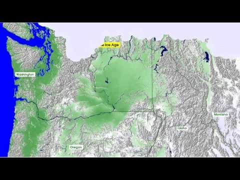
The ancestral Palouse River flowed through the currently dry Washtucna Coulee to the Columbia River. The Palouse Falls and surrounding canyons were created when the Missoula floods overtopped the south valley wall of the ancestral Palouse River, diverting it to the current course to the Snake River by erosion of a new channel.[3][6]
Geologist J Harlen Bretz defined "scablands" in a series of papers written in the 1920s as lowlands diversified by a multiplicity of irregular channels and rock basins eroded into basalt. Flood waters eroded the loess cover, creating large anastomizing channels which exposed bare basalt and creating butte-and-basin topography. The buttes range in height from 30 to 100 m, while the rock basins range from 10 m in width up to the 11 km long and 30 m deep Rock Lake. Bretz further stated, "The channels run uphill and downhill, they unite and they divide, they head on the back-slopes and cut through the summit; they could not be more erratically and impossibly designed."[7] -
I like big buttes and I cannot lie.PurpleThrobber said:
Yes and no. The flood did some serious carving - but the basalt which is fucking everywhere in the Palouse/Coulees is volcanic.pawz said:
Not to be tickey-tackey, but how do you mean Palouse Falls is volcanic in nature? Obviously that area has had multiple rounds of pyroclastic flows cover. Anyone can see the layers in the rock in the photos. As I understand it, Palouse Falls was dug out of those said flows and layers by an unfathomable amount of fast moving water.PurpleThrobber said:
Lake Missoula most definitely covered Palouse Falls - but that feature is volcanic in nature. The surrounding sod-buster fine loess soil (whereby the name "Palouse" derived) is from the silt spread out over a good chunk of E. Washington by the flow of the Lake Missoula water getting after it.
#dirtsuperiorityguy
I'm not expert for sure, however it seems that the Palouse Soil settled as the floods were receding? Hence a large area is called scabbed lands. Obviously the water flow required to carve out igneous rock would have taken any loose soil with it rather easily.
Either way it was interesting.
The ancestral Palouse River flowed through the currently dry Washtucna Coulee to the Columbia River. The Palouse Falls and surrounding canyons were created when the Missoula floods overtopped the south valley wall of the ancestral Palouse River, diverting it to the current course to the Snake River by erosion of a new channel.[3][6]
Geologist J Harlen Bretz defined "scablands" in a series of papers written in the 1920s as lowlands diversified by a multiplicity of irregular channels and rock basins eroded into basalt. Flood waters eroded the loess cover, creating large anastomizing channels which exposed bare basalt and creating butte-and-basin topography. The buttes range in height from 30 to 100 m, while the rock basins range from 10 m in width up to the 11 km long and 30 m deep Rock Lake. Bretz further stated, "The channels run uphill and downhill, they unite and they divide, they head on the back-slopes and cut through the summit; they could not be more erratically and impossibly designed."[7] -
Slide slide slippity-slideYellowSnow said:
I like big buttes and I cannot lie.PurpleThrobber said:
Yes and no. The flood did some serious carving - but the basalt which is fucking everywhere in the Palouse/Coulees is volcanic.pawz said:
Not to be tickey-tackey, but how do you mean Palouse Falls is volcanic in nature? Obviously that area has had multiple rounds of pyroclastic flows cover. Anyone can see the layers in the rock in the photos. As I understand it, Palouse Falls was dug out of those said flows and layers by an unfathomable amount of fast moving water.PurpleThrobber said:
Lake Missoula most definitely covered Palouse Falls - but that feature is volcanic in nature. The surrounding sod-buster fine loess soil (whereby the name "Palouse" derived) is from the silt spread out over a good chunk of E. Washington by the flow of the Lake Missoula water getting after it.
#dirtsuperiorityguy
I'm not expert for sure, however it seems that the Palouse Soil settled as the floods were receding? Hence a large area is called scabbed lands. Obviously the water flow required to carve out igneous rock would have taken any loose soil with it rather easily.
Either way it was interesting.
The ancestral Palouse River flowed through the currently dry Washtucna Coulee to the Columbia River. The Palouse Falls and surrounding canyons were created when the Missoula floods overtopped the south valley wall of the ancestral Palouse River, diverting it to the current course to the Snake River by erosion of a new channel.[3][6]
Geologist J Harlen Bretz defined "scablands" in a series of papers written in the 1920s as lowlands diversified by a multiplicity of irregular channels and rock basins eroded into basalt. Flood waters eroded the loess cover, creating large anastomizing channels which exposed bare basalt and creating butte-and-basin topography. The buttes range in height from 30 to 100 m, while the rock basins range from 10 m in width up to the 11 km long and 30 m deep Rock Lake. Bretz further stated, "The channels run uphill and downhill, they unite and they divide, they head on the back-slopes and cut through the summit; they could not be more erratically and impossibly designed."[7]
I do what I do just to survive
_Couleeo
-
*juiceGrundleStiltzkin said:
Til the sluice runs down my legYellowSnow said:
I keep a coolie baby. - Robert Plant, 1969PurpleThrobber said:GrundleStiltzkin said:Channeled Scablands is a great name.
 https://www.youtube.com/watch?v=G_LRo3wIT34
I prefer to more politically incorrect word "Coolies".
Err...I mean "Coulees"

