Favorite Geologic Feature, Cataclysmic Floods, and JRE

What we now know to be true, is there was cataclysmic flooding all over North America, in particular the Pacific Northwest, at the end of the Younger Dryas period about 11,800 years ago. This is due to rapid melting of the ice sheets and the end of Ice Age. There are a couple theories about what caused the rapid melt-water event - a series of comet impacts and massive solar flares to name a few.
Yella had made the comment from the Gorge photo that Lake Missoula emptied through there, and I don't know that is exactly true. I think Lake Missoula emptied through Palouse Falls - likely abundance. There was LOT of fucking water. So much so, world-wide sea levels rose 400 feet.
Palouse Falls

The Gorge - Gorge Amphetheater is just out of sight to the right of the picture. And for scale, that scar in the landscape is 5 MILES across. It took a lot of fucking water to make that, which Carlson breaks down in the above links

Lake Missoula - I took this photo when I saw PJ in Missoula this summer. You can see the striations in the hillside from when water filled the valley. The mind numbing part of this after seeing the obvious water marks, is when you look to see the other side of the valley and it's so far away you can't see it. You are standing the the bottom of what was very much an ocean.

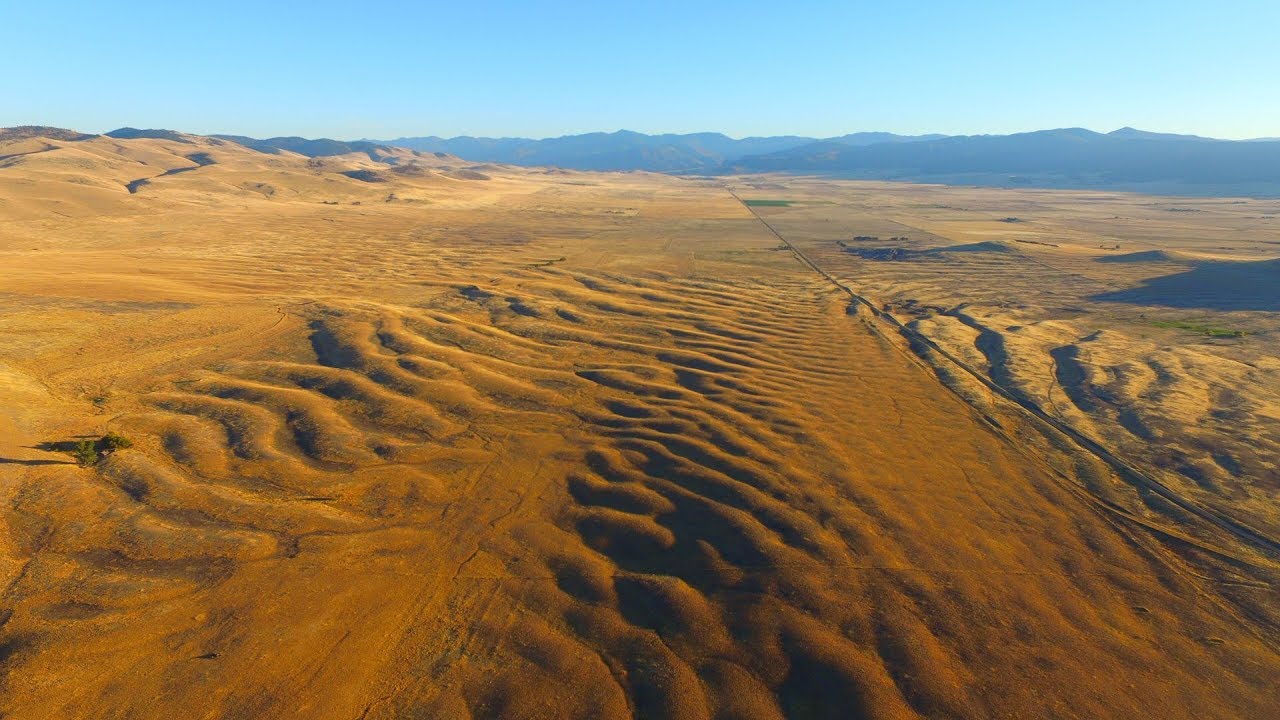
Camas Prairie, MT - In this photo the layman can tell you those are obvious water ripples, like what you see walking on the beach for perspective. The mind-numbing part is that those ripples are 50 FEET tall (five stories high).
Mouth of Mosess Coulee into Columbia River Valley

Grand Coulee Dam in the foreground. Obvious scar from flooding behind.
Below, Randal Carlson is the real genius when it comes to piecing together all the geologic clues. Carlson goes into great detail about the quantity, force and flows required to scare the landscape the way it did. It's truly unfathomable. If one has the inclination, its very easy to nerd-out on all of Carlson's slides, graphs and other scientific data.
Joe & Graham Hancock
#142 -
 https://www.youtube.com/watch?v=3ODaWxBJNPk
 #360 -
 https://www.youtube.com/watch?v=tsu2-I2q6dg
 #417 -
 https://www.youtube.com/watch?v=1cbnCrHwVSg
 #551 -
 https://www.youtube.com/watch?v=W7zfnNH1GD0
Joe & Randall Carlson - http://sacredgeometryinternational.com/randall-carlson
#501 -
 https://www.youtube.com/watch?v=R31SXuFeX0A
#606 -
 https://www.youtube.com/watch?v=G0Cp7DrvNLQ
 Joe & Graham & Randal
#725 -
 https://www.youtube.com/watch?v=aDejwCGdUV8
#872 -
 https://www.youtube.com/watch?v=0H5LCLljJho
#961 -
 https://www.youtube.com/watch?v=tFlAFo78xoQ
Comments
-
interesting, thank you
-
I thought your pic that commented on was Dry Falls lake which was definitely Missoula Flood. But still...
-

Lake Missoula most definitely covered Palouse Falls - but that feature is volcanic in nature. The surrounding sod-buster fine loess soil (whereby the name "Palouse" derived) is from the silt spread out over a good chunk of E. Washington by the flow of the Lake Missoula water getting after it.
#dirtsuperiorityguy
-
Channeled Scablands is a great name.
-
GrundleStiltzkin said:
Channeled Scablands is a great name.
 https://www.youtube.com/watch?v=G_LRo3wIT34
I prefer to more politically incorrect word "Coolies".
Err...I mean "Coulees"
-
I keep a coolie baby. - Robert Plant, 1969PurpleThrobber said:GrundleStiltzkin said:Channeled Scablands is a great name.
https://www.youtube.com/watch?v=G_LRo3wIT34
I prefer to more politically incorrect word "Coolies".
Err...I mean "Coulees" -
Til the sluice runs down my legYellowSnow said:
I keep a coolie baby. - Robert Plant, 1969PurpleThrobber said:GrundleStiltzkin said:Channeled Scablands is a great name.
https://www.youtube.com/watch?v=G_LRo3wIT34
I prefer to more politically incorrect word "Coolies".
Err...I mean "Coulees" -
Squeeze my magma
-
-
Not to be tickey-tackey, but how do you mean Palouse Falls is volcanic in nature? Obviously that area has had multiple rounds of pyroclastic flows cover. Anyone can see the layers in the rock in the photos. As I understand it, Palouse Falls was dug out of those said flows and layers by an unfathomable amount of fast moving water.PurpleThrobber said:
Lake Missoula most definitely covered Palouse Falls - but that feature is volcanic in nature. The surrounding sod-buster fine loess soil (whereby the name "Palouse" derived) is from the silt spread out over a good chunk of E. Washington by the flow of the Lake Missoula water getting after it.
#dirtsuperiorityguy
I'm not expert for sure, however it seems that the Palouse Soil settled as the floods were receding? Hence a large area is called scabbed lands. Obviously the water flow required to carve out igneous rock would have taken any loose soil with it rather easily. -
Yes and no. The flood did some serious carving - but the basalt which is fucking everywhere in the Palouse/Coulees is volcanic.pawz said:
Not to be tickey-tackey, but how do you mean Palouse Falls is volcanic in nature? Obviously that area has had multiple rounds of pyroclastic flows cover. Anyone can see the layers in the rock in the photos. As I understand it, Palouse Falls was dug out of those said flows and layers by an unfathomable amount of fast moving water.PurpleThrobber said:
Lake Missoula most definitely covered Palouse Falls - but that feature is volcanic in nature. The surrounding sod-buster fine loess soil (whereby the name "Palouse" derived) is from the silt spread out over a good chunk of E. Washington by the flow of the Lake Missoula water getting after it.
#dirtsuperiorityguy
I'm not expert for sure, however it seems that the Palouse Soil settled as the floods were receding? Hence a large area is called scabbed lands. Obviously the water flow required to carve out igneous rock would have taken any loose soil with it rather easily.
Either way it was interesting.
The ancestral Palouse River flowed through the currently dry Washtucna Coulee to the Columbia River. The Palouse Falls and surrounding canyons were created when the Missoula floods overtopped the south valley wall of the ancestral Palouse River, diverting it to the current course to the Snake River by erosion of a new channel.[3][6]
Geologist J Harlen Bretz defined "scablands" in a series of papers written in the 1920s as lowlands diversified by a multiplicity of irregular channels and rock basins eroded into basalt. Flood waters eroded the loess cover, creating large anastomizing channels which exposed bare basalt and creating butte-and-basin topography. The buttes range in height from 30 to 100 m, while the rock basins range from 10 m in width up to the 11 km long and 30 m deep Rock Lake. Bretz further stated, "The channels run uphill and downhill, they unite and they divide, they head on the back-slopes and cut through the summit; they could not be more erratically and impossibly designed."[7] -
I like big buttes and I cannot lie.PurpleThrobber said:
Yes and no. The flood did some serious carving - but the basalt which is fucking everywhere in the Palouse/Coulees is volcanic.pawz said:
Not to be tickey-tackey, but how do you mean Palouse Falls is volcanic in nature? Obviously that area has had multiple rounds of pyroclastic flows cover. Anyone can see the layers in the rock in the photos. As I understand it, Palouse Falls was dug out of those said flows and layers by an unfathomable amount of fast moving water.PurpleThrobber said:
Lake Missoula most definitely covered Palouse Falls - but that feature is volcanic in nature. The surrounding sod-buster fine loess soil (whereby the name "Palouse" derived) is from the silt spread out over a good chunk of E. Washington by the flow of the Lake Missoula water getting after it.
#dirtsuperiorityguy
I'm not expert for sure, however it seems that the Palouse Soil settled as the floods were receding? Hence a large area is called scabbed lands. Obviously the water flow required to carve out igneous rock would have taken any loose soil with it rather easily.
Either way it was interesting.
The ancestral Palouse River flowed through the currently dry Washtucna Coulee to the Columbia River. The Palouse Falls and surrounding canyons were created when the Missoula floods overtopped the south valley wall of the ancestral Palouse River, diverting it to the current course to the Snake River by erosion of a new channel.[3][6]
Geologist J Harlen Bretz defined "scablands" in a series of papers written in the 1920s as lowlands diversified by a multiplicity of irregular channels and rock basins eroded into basalt. Flood waters eroded the loess cover, creating large anastomizing channels which exposed bare basalt and creating butte-and-basin topography. The buttes range in height from 30 to 100 m, while the rock basins range from 10 m in width up to the 11 km long and 30 m deep Rock Lake. Bretz further stated, "The channels run uphill and downhill, they unite and they divide, they head on the back-slopes and cut through the summit; they could not be more erratically and impossibly designed."[7] -
Slide slide slippity-slideYellowSnow said:
I like big buttes and I cannot lie.PurpleThrobber said:
Yes and no. The flood did some serious carving - but the basalt which is fucking everywhere in the Palouse/Coulees is volcanic.pawz said:
Not to be tickey-tackey, but how do you mean Palouse Falls is volcanic in nature? Obviously that area has had multiple rounds of pyroclastic flows cover. Anyone can see the layers in the rock in the photos. As I understand it, Palouse Falls was dug out of those said flows and layers by an unfathomable amount of fast moving water.PurpleThrobber said:
Lake Missoula most definitely covered Palouse Falls - but that feature is volcanic in nature. The surrounding sod-buster fine loess soil (whereby the name "Palouse" derived) is from the silt spread out over a good chunk of E. Washington by the flow of the Lake Missoula water getting after it.
#dirtsuperiorityguy
I'm not expert for sure, however it seems that the Palouse Soil settled as the floods were receding? Hence a large area is called scabbed lands. Obviously the water flow required to carve out igneous rock would have taken any loose soil with it rather easily.
Either way it was interesting.
The ancestral Palouse River flowed through the currently dry Washtucna Coulee to the Columbia River. The Palouse Falls and surrounding canyons were created when the Missoula floods overtopped the south valley wall of the ancestral Palouse River, diverting it to the current course to the Snake River by erosion of a new channel.[3][6]
Geologist J Harlen Bretz defined "scablands" in a series of papers written in the 1920s as lowlands diversified by a multiplicity of irregular channels and rock basins eroded into basalt. Flood waters eroded the loess cover, creating large anastomizing channels which exposed bare basalt and creating butte-and-basin topography. The buttes range in height from 30 to 100 m, while the rock basins range from 10 m in width up to the 11 km long and 30 m deep Rock Lake. Bretz further stated, "The channels run uphill and downhill, they unite and they divide, they head on the back-slopes and cut through the summit; they could not be more erratically and impossibly designed."[7]
I do what I do just to survive
_Couleeo
-
*juiceGrundleStiltzkin said:
Til the sluice runs down my legYellowSnow said:
I keep a coolie baby. - Robert Plant, 1969PurpleThrobber said:GrundleStiltzkin said:Channeled Scablands is a great name.
https://www.youtube.com/watch?v=G_LRo3wIT34
I prefer to more politically incorrect word "Coolies".
Err...I mean "Coulees"


